| [ Login ]/[ Register ] |
 Search ::
  My Data Basket ::
  Favorite/My Favorite :: Recent Changes :: :: Login Save in Data Basket ]
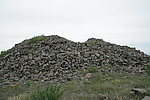
| Caption:黄土囫囵07号烽火台 Photo Time:2007-07-20 10:45:22 Photo Contributor:河北省文物局 [Open in New Window] |
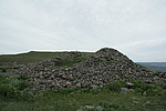
| Caption:黄土囫囵07号烽火台 Photo Time:2007-07-20 10:45:52 Photo Contributor:河北省文物局 [Open in New Window] |
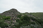
| Caption:黄土囫囵07号烽火台 Photo Time:2007-07-20 10:46:14 Photo Contributor:河北省文物局 [Open in New Window] |
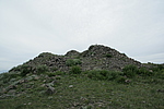
| Caption:黄土囫囵07号烽火台 Photo Time:2007-07-20 10:47:30 Photo Contributor:河北省文物局 [Open in New Window] |