| [ Login ]/[ Register ] |
 Search ::
  My Data Basket ::
  Favorite/My Favorite :: Recent Changes :: :: Login Save in Data Basket ]
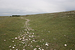
| Caption:上圪瘩长城2段 Photo Time:2008-06-18 16:37:25 Photo Contributor:青海省文物局 [Open in New Window] |
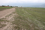
| Caption:上圪瘩长城2段 Photo Time:2008-06-18 16:41:10 Photo Contributor:青海省文物局 [Open in New Window] |
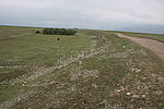
| Caption:上圪瘩长城2段 Photo Time:2008-06-18 16:41:18 Photo Contributor:青海省文物局 [Open in New Window] |
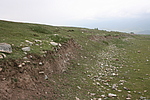
| Caption:上圪瘩长城2段 Photo Time:2008-06-18 16:45:50 Photo Contributor:青海省文物局 [Open in New Window] |